U
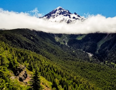
@dalenpdx - UnsplashMt Hood
📍 Frá Bald Mountain - Timberline Trail #600, United States
Mt Hood og Bald Mountain eru hluti af Cascade-keðjunni í bandaríska ríki Oregon. Með hæð upp á 11.249 fet er Mt Hood eldfjallaáreitur og hæsta fjallið í ríkinu. Timberline Trail #600 leiðir framhjá toppi þess og nálægum Bald Mountain og býður upp á stórkostlegt útsýni yfir Mt Hood og jökla, gíga og gróandi grænni skóga. Það er frábær staður fyrir dagsferð eða bakpokasamferð. Stíginn er talinn meðalleiðan og tekur yfirleitt 2–5 daga að ganga 40 mílna hringrás. Langs stígsins eru nokkrir myndrænir tjaldbúðarstaðir og nokkrir píknikpallar með útsýni yfir toppinn. Með litríkum villtum blómum á sumrin og málarískum snjólandslögum á veturna er þetta frábær staður fyrir göngumenn, náttúruunnendur og ljósmyndara.
🗺 Kort
🎫 Ferðamannastaðir
🌦 Veðurupplýsingar
Fáðu veðurupplýsingar, og margt fleira, frá appinu. Sæktu það frítt!
🚕 Hvernig á að komast þangað?
Fáðu leiðarupplýsingar (með bíl, gangandi, almenningssamgöngum, o.s.frv.), og margt fleira, frá appinu. Sæktu það frítt!