NoFilter

Mt Hood

私たちのアプリは、旅行者や写真家が世界中の最高の写真の場所を見つけるのに役立ちます

Mt Hood - から Bald Mountain - Timberline Trail #600, United States
U
@dalenpdx - Unsplash
Mt Hood
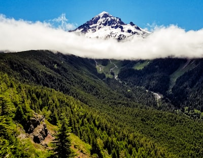
📍 から Bald Mountain - Timberline Trail #600, United States
Mt Hood and Bald Mountain are part of the Cascade Range in the U.S. state of Oregon. Situated at an elevation of 11,249 feet, Mt Hood is a volcanic peak and the highest mountain in the state. The Timberline Trail #600 passes by its summit and nearby Bald Mountain, offering stunning views of Mount Hood and its glaciers, craters and lush green forests. It is an excellent place for a day hike or backpacking trip. The trail is considered moderate and typically takes 2-5 days to complete the 40 mile loop. There are a number of scenic campsites along the trail and a few picnic benches with views of the summit. With colorful wildflowers in summer and picturesque snowscapes in winter, it's a great spot for hikers, nature lovers and photographers alike.

🗺 地図

🎫 観光名所

🏨 ホステル

🌦 気象情報

アプリから天気情報などを取得します。無料でダウンロードしてください!

🚕 そこに着く方法?

アプリからルート情報 (車、徒歩、公共交通機関など) などを入手できます。無料でダウンロードしてください!
もっと見たいです?
アプリをダウンロードします。それは無料です!