U
@evanmcmenamin - UnsplashFort Dunree
📍 Desde Viewpoint, Ireland
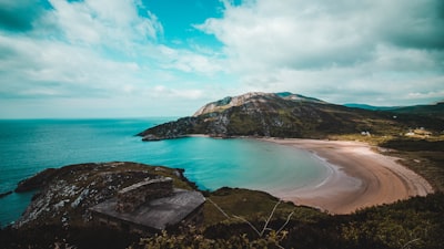
Ubicado directamente en la costa de Lough Swilly en el condado de Donegal, Fort Dunree es una fortificación militar del siglo XIX. Se sitúa alto en un acantilado que domina Dunree Head, que es un paisaje escarpado e impresionante en la entrada a la bahía de Donegal.
El sitio fue originalmente un fuerte en un promontorio de la Edad del Hierro, ocupado por primera vez por la familia O’Doherty en el siglo X. Durante la Segunda Guerra Mundial, el fuerte fue convertido para su uso como un puesto naval británico. Más tarde, se utilizó como campo de entrenamiento para las Fuerzas de Defensa Irlandesas y ahora es la sede del Servicio Naval Irlandés. Hoy en día, Fort Dunree es una atracción turística popular. Los visitantes encontrarán dos edificios de museo en el sitio con cinco áreas de exhibición dedicadas a la historia militar irlandesa desde el siglo XIX hasta la actualidad. También hay visitas guiadas al fuerte y a sus galerías subterráneas, que fueron construidas en 1798. Un camino lleva por la cara empinada del acantilado hasta una playa rocosa; los restos de una antigua instalación de armas se pueden ver a lo largo del camino. El área tiene muchas características geológicas interesantes, como cuevas marinas, arcos y un barco hundido. También en el lugar se encuentran varias especies de flores silvestres, únicas en esta región de Irlanda. Fort Dunree es un sitio histórico fascinante y un lugar ideal para explorar la costa escarpada de Donegal.
El sitio fue originalmente un fuerte en un promontorio de la Edad del Hierro, ocupado por primera vez por la familia O’Doherty en el siglo X. Durante la Segunda Guerra Mundial, el fuerte fue convertido para su uso como un puesto naval británico. Más tarde, se utilizó como campo de entrenamiento para las Fuerzas de Defensa Irlandesas y ahora es la sede del Servicio Naval Irlandés. Hoy en día, Fort Dunree es una atracción turística popular. Los visitantes encontrarán dos edificios de museo en el sitio con cinco áreas de exhibición dedicadas a la historia militar irlandesa desde el siglo XIX hasta la actualidad. También hay visitas guiadas al fuerte y a sus galerías subterráneas, que fueron construidas en 1798. Un camino lleva por la cara empinada del acantilado hasta una playa rocosa; los restos de una antigua instalación de armas se pueden ver a lo largo del camino. El área tiene muchas características geológicas interesantes, como cuevas marinas, arcos y un barco hundido. También en el lugar se encuentran varias especies de flores silvestres, únicas en esta región de Irlanda. Fort Dunree es un sitio histórico fascinante y un lugar ideal para explorar la costa escarpada de Donegal.
🗺 Mapa
🎫 Atracciones turísticas
🌦 Información del clima
Obtén información del clima, y mucho más, desde la app. ¡Descárgala gratis!
🚕 ¿Cómo llegar?
Obtén información de rutas (en coche, a pie, transporte público, etc.), y mucho más, desde la app. ¡Descárgala gratis!