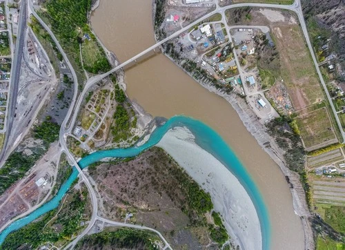
Cayoosh Creek es una impresionante muestra de dos ríos, el Harrison y el Fraser, uniéndose. Ubicado en la Reserva Indígena de Lillooet, este sitio ofrece vistas impresionantes y es un lugar popular para picnics y caminatas. Las rocas, árboles y el agua azul clara que lo rodean constituyen algunas de las fotos más impresionantes de toda Columbia Británica. A lo largo de las orillas se encuentran numerosas playas e islas, fauna, exuberante vegetación ribereña y ocasionales cascadas. Disfruta de impresionantes amaneceres y atardeceres, busca fauna y explora las playas rocosas. Ya sea que ames la naturaleza o seas un fotógrafo aficionado, Cayoosh Creek es el lugar perfecto para capturar algunos de los paisajes más bellos de Columbia Británica.
TOP
🗺 Mapa
🎫 Atracciones turísticas
🌦 Información del clima
Obtén información del clima, y mucho más, desde la app. ¡Descárgala gratis!
🚕 ¿Cómo llegar?
Obtén información de rutas (en coche, a pie, transporte público, etc.), y mucho más, desde la app. ¡Descárgala gratis!