U
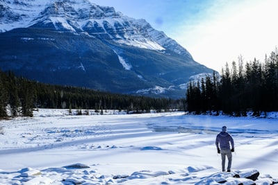
@emcomeau - UnsplashAthabasca River
📍 Desde Frozen Falls, Canada
El río Athabasca es uno de los principales ríos de Canadá. Comienza en el campo de hielo Columbia en las Montañas Rocosas del Parque Nacional Jasper y fluye más de 1,000 kilómetros hacia el norte hasta el lago Athabasca en la provincia de Alberta. A lo largo del camino, el río se convierte en parte de las arenas bituminosas de Athabasca, el mayor depósito de petróleo crudo del mundo. Desde allí, el río se une con otros ríos, incluidos el Hinton, el Athabasca, el Pembina y el Cañón Athabasca. A lo largo de su curso, el río atraviesa una variedad de paisajes, incluyendo montañas, bosques y humedales, creando una diversa gama de hábitats y vida silvestre. Durante los meses de verano, el río es popular entre los aficionados al rafting en aguas bravas y los canoístas, mientras que sus orillas ofrecen muchas oportunidades para una variedad de actividades, incluyendo acampar, pescar, hacer senderismo y observar la vida silvestre. La fauna incluye osos grizzly, osos negros, lobos, glotones, alces, uapitíes, castores, águilas calvas, águilas pescadoras y grullas canadienses. El río Athabasca es también uno de los ríos más claros y limpios de Canadá. Ya sea en coche o a pie, los visitantes pueden disfrutar de su belleza natural durante horas.
🗺 Mapa
🎫 Atracciones turísticas
🌦 Información del clima
Obtén información del clima, y mucho más, desde la app. ¡Descárgala gratis!
🚕 ¿Cómo llegar?
Obtén información de rutas (en coche, a pie, transporte público, etc.), y mucho más, desde la app. ¡Descárgala gratis!