U
@andreasfelske - UnsplashSuðurlandsvegur
📍 From Drone, Iceland
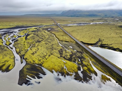
Suðurlandsvegur, in English the South Coast Road, is a 135 km long highway located in the Southern Region of Iceland, passing through the towns of Hvolsvöllur, Vík, and Kirkjubæjarklaustur. The route offers stunning views of the wild coast and highlands, black sand beaches, glaciers and stunning waterfalls. This is one of the main tourist routes in Iceland offering views of popular sights such as Skógafoss, Seljalandsfoss, Sólheimajökull, Reynisdrangar, and the Fimmvörðuháls Pass, Vestmannaeyjar (the Westman Islands) and the iconic rock formation Reynisdrangar in Reynisfjara. It is a great spot for wildlife spotting and a chance to explore with abandoned planes, old churches, and Viking ruins. The route is easy to traverse, with well-maintained roads and tourist information signs at several points along the route.
🗺 Map
🎫 Tourist attractions
🏨 Hostels
🌦 Weather information
Get weather information, and much more, from the app. Download it for free!
🚕 How to get there?
Get routes information (by car, walking, public transport, etc), and much more, from the app. Download it for free!