U
@dalenpdx - UnsplashMt Hood
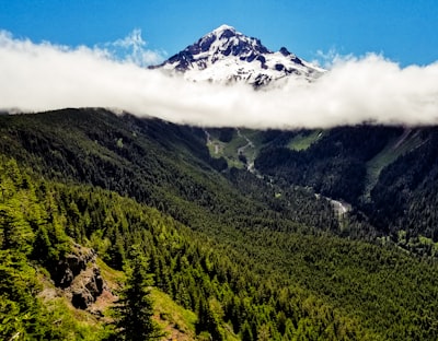
📍 From Bald Mountain - Timberline Trail #600, United States
Mt Hood and Bald Mountain are part of the Cascade Range in the U.S. state of Oregon. Situated at an elevation of 11,249 feet, Mt Hood is a volcanic peak and the highest mountain in the state. The Timberline Trail #600 passes by its summit and nearby Bald Mountain, offering stunning views of Mount Hood and its glaciers, craters and lush green forests. It is an excellent place for a day hike or backpacking trip. The trail is considered moderate and typically takes 2-5 days to complete the 40 mile loop. There are a number of scenic campsites along the trail and a few picnic benches with views of the summit. With colorful wildflowers in summer and picturesque snowscapes in winter, it's a great spot for hikers, nature lovers and photographers alike.
🗺 Map
🎫 Tourist attractions
🌦 Weather information
Get weather information, and much more, from the app. Download it for free!
🚕 How to get there?
Get routes information (by car, walking, public transport, etc), and much more, from the app. Download it for free!