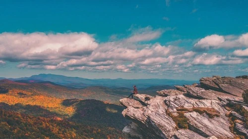
Hawksbill Mountain is a scenic mountain located in Spruce Pine, North Carolina, United States. Standing at an elevation of 5,520 feet, it is the highest point in the South Toe River Valley and an important part of the Linville Gorge Wilderness area. It has a flat top, made of coarse-grained pink granite that provides a unique landscape and attractions for hikers, and photographers in particular. Despite its humble peak, Hawksbill Mountain is one of the most impressive hikes in the area. To reach the summit, hikers will have to climb 1,500 feet in elevation over estimately 4.5 miles. On the way, you’ll be rewarded with amazing views of the Linville Gorge Wilderness Area, passing by rock outcroppings and patches of vegetation. The summit also offers an incredible 360-degree panorama. From up top, you will be able to see across the Blue Ridge Mountains and see sites such as Table Rock and Grandfather Mountain. Hawksbill Mountain is just one of the many great photographic opportunities you can find in the North Carolina Mountains.
TOP
🗺 Map
🎫 Tourist attractions
🏨 Hostels
🌦 Weather information
Get weather information, and much more, from the app. Download it for free!
🚕 How to get there?
Get routes information (by car, walking, public transport, etc), and much more, from the app. Download it for free!