U
@lexmelony - UnsplashÞingvellir National Park
📍 From Drone, Iceland
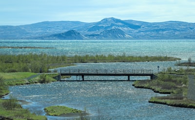
Þingvellir National Park is located in south-west Iceland, only 45km from Reykjavík. It is one of the most popular tourist attractions in the country, and is visited by hundreds of thousands of people each year.
The park is renowned for its geological feature, the Almannagjá rift, which is the meeting point of the North American and Eurasian tectonic plates. This is where, in around 930 AD, the first national parliament in the world was founded. The ruins of the parliament buildings can be found in the park today. Þingvellir National Park is also home to a great variety of plants and wildlife, including a number of protected species. One of the main attractions is the clear and transparent glacial lake, Þingvallavatn, which is a popular spot for wildlife watching, particularly fishing. The park is also part of the "Golden Circle," a popular route which takes visitors to the nearby Gullfoss waterfall and the geysers at Haukadalur. Þingvellir is the perfect place for nature lovers, history buffs, and photographers alike.
The park is renowned for its geological feature, the Almannagjá rift, which is the meeting point of the North American and Eurasian tectonic plates. This is where, in around 930 AD, the first national parliament in the world was founded. The ruins of the parliament buildings can be found in the park today. Þingvellir National Park is also home to a great variety of plants and wildlife, including a number of protected species. One of the main attractions is the clear and transparent glacial lake, Þingvallavatn, which is a popular spot for wildlife watching, particularly fishing. The park is also part of the "Golden Circle," a popular route which takes visitors to the nearby Gullfoss waterfall and the geysers at Haukadalur. Þingvellir is the perfect place for nature lovers, history buffs, and photographers alike.
🗺 Map
🎫 Tourist attractions
🌦 Weather information
Get weather information, and much more, from the app. Download it for free!
🚕 How to get there?
Get routes information (by car, walking, public transport, etc), and much more, from the app. Download it for free!