U
@nextvoyage_pl - UnsplashMöðrudalsleið
📍 Z Drone, Iceland
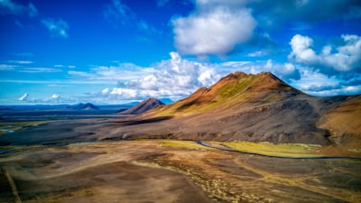
Möðrudalsleið is a great place to explore and experience the wild landscapes of Iceland. It is a 3km gravel road that winds its way from the town of Vidhidalur to Gýgjarfoss Waterfall and beyond. The drive takes you through vast stretches of barren lava desert, winding through and between rocky outcrops and over incredible black sand plains. The best part of this drive is the views, which are framed by the towering mountains that rise on all sides. Since the road leads up to the nearby Gýgjarfoss Waterfall, you can enjoy a breathtaking view of the powerful cascade of water. The drive also provides many opportunities for great photography, with its raw Icelandic landscape, craggy mountains, and dark volcanic sands. Be sure to come with good shoes and a four-wheel-drive vehicle, as the bumpy gravel terrain is not suitable for all vehicles.
🗺 Mapa
🎫 Turistické atrakce
🏨 Ubytovny
🌦 Informace o počasí
Získejte informace o počasí a mnohem více z aplikace. Stáhněte si ji zdarma!
🚕 Jak se tam dostat?
Získejte informace o trasách (autem, pěšky, veřejnou dopravou atd.) a mnohem více z aplikace. Stáhněte si ji zdarma!